| Navigation: | ||||||||||||||||||||||||||||||||||||||||||||||||||||||||||||||||||||||||||||||||||||||||||||||||||||||||||||||||||||||||||||||||||||
| The primary method of navigation aboard U-boats was by sextant. Position was calculated and plotted in degrees, minutes and tenths of minutes of latitude and longitude. In order to transmit positions efficiently and reliably over the radio, the Kriegsmarine used a system of grid squares. The Kriegsmarine used a map of the world's oceans laid out in squares with the first two characters (BC 1857 for example) identifying the large square and the next 4 characters (BC 1857 for example) identifying the position within that square. When all six characters were given, a typical grid square was 6 x 6 nm. See the links below for an explanation of this system. Only first two characters were given when referring to just the large square and zeros were substituted for the numbers if a less specific position was intended. In radio messages the grids were often reported in coded form by using a pre-defined offset and /or encoding the letters and numbers with reference to a code book (Adressbuch) carried for that purpose. | ||||||||||||||||||||||||||||||||||||||||||||||||||||||||||||||||||||||||||||||||||||||||||||||||||||||||||||||||||||||||||||||||||||
Click the icon to explore and practice German WWII era celestial navigation |
||||||||||||||||||||||||||||||||||||||||||||||||||||||||||||||||||||||||||||||||||||||||||||||||||||||||||||||||||||||||||||||||||||
|
||||||||||||||||||||||||||||||||||||||||||||||||||||||||||||||||||||||||||||||||||||||||||||||||||||||||||||||||||||||||||||||||||||
Click the icon to proceed to pages describing the Kriegsmarine grid system |
||||||||||||||||||||||||||||||||||||||||||||||||||||||||||||||||||||||||||||||||||||||||||||||||||||||||||||||||||||||||||||||||||||
|
||||||||||||||||||||||||||||||||||||||||||||||||||||||||||||||||||||||||||||||||||||||||||||||||||||||||||||||||||||||||||||||||||||
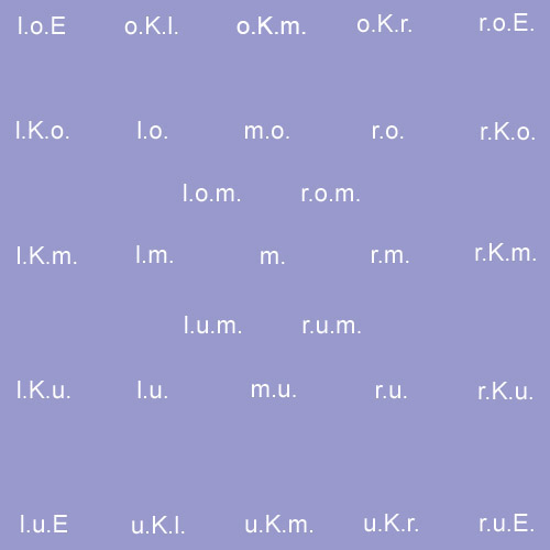
Some commanders used unofficial additions to the grids to write down their position more precisely. These were written as various abbreviations from one to three letters behind the six characters of the Naval grid system to give the exact position within the small square. The combinations used were put together from these six abbreviations: |
||||||||||||||||||||||||||||||||||||||||||||||||||||||||||||||||||||||||||||||||||||||||||||||||||||||||||||||||||||||||||||||||||||
|
||||||||||||||||||||||||||||||||||||||||||||||||||||||||||||||||||||||||||||||||||||||||||||||||||||||||||||||||||||||||||||||||||||
| For example, “l.o.E.” means left upper corner and “r.K.m.” is the middle of the right edge. The image below shows where these positions were located within a grid square. | ||||||||||||||||||||||||||||||||||||||||||||||||||||||||||||||||||||||||||||||||||||||||||||||||||||||||||||||||||||||||||||||||||||
 |
||||||||||||||||||||||||||||||||||||||||||||||||||||||||||||||||||||||||||||||||||||||||||||||||||||||||||||||||||||||||||||||||||||
| In addition to the abbreviations above, sometimes the CO might refer to the edge of a square using the abbreviations, l.K., r.K., o.K. or u.K. The order of the letters in the abbreviations is variable so l.o. might appear as o.l or r.K.m. might appear as m.r.K. (except as noted below). For the purpose of translating the following convention will be adopted. | ||||||||||||||||||||||||||||||||||||||||||||||||||||||||||||||||||||||||||||||||||||||||||||||||||||||||||||||||||||||||||||||||||||
|
||||||||||||||||||||||||||||||||||||||||||||||||||||||||||||||||||||||||||||||||||||||||||||||||||||||||||||||||||||||||||||||||||||