U-116 - 3rd War Patrol
Translation by Jerry Mason with the help Andi Forster
Departed |
Date |
Arrived |
Date |
Days at Sea |
Lorient |
27 June 1942 |
Lorient |
23 August 1942 |
58 |
| Click the icon to download a KMZ file displaying the U-boat track, significant events and locations for this patrol. You must have Google Earth loaded on your computer to view this file. Download Google Earth here |
Ships Hit |
||||||
Date |
KTB Time |
Position |
Ship |
Tons |
Nationality |
Convoy |
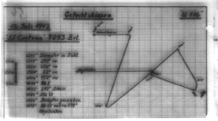
12 Jul 42 |
00.22 |
32°03'N,
24°38'W |
CORTONA (damaged) |
7,093 |
British |
OS-33 |
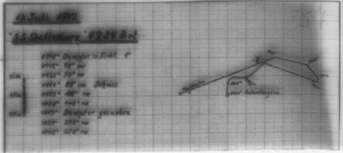
12 Jul 42
|
09.45 |
31°33'N,
25°26'W |
SHAFTESBURY |
4,284 |
British |
OS-33 |
Total = 11,377 |
||||||
| Note: The positions in the table above and in the Google Earth patrol summary are derived from the KTB and in many cases do not match those set forth in authoritative references such as Jürgen Rohwer, Axis Submarine Successes of World War Two or the Uboat.net website. The goal here is to present the picture relative to the U-boat and not the absolute position that the ship was attacked or sank. | ||||||
|
|||||||||||||||||||||||||
|
|||||||||||||||||||||||||
| K r i e g s t a g e b u c h | |||||||||||||||||||||||||
| -=-=-=-=-=-=-=-=-=-=-=-=-=-=- | |||||||||||||||||||||||||
| of the | |||||||||||||||||||||||||
| Unterseebootes "U 1 1 6 " | |||||||||||||||||||||||||
| -=-=-=-=-=-=-=-=-=-=-=-=-=- | |||||||||||||||||||||||||
| Kommandant : | Korv.Kapt. Werner von Schmidt | ||||||||||||||||||||||||
| Beginning : | 9 June 1942. | ||||||||||||||||||||||||
| Concluding : | 23 August 1942. | ||||||||||||||||||||||||
| ----------- | |||||||||||||||||||||||||
|
|||||||||||||||||||||||||
|
|||||||||||||||||||||||||
| © U-boat Archive 2023 - all rights reserved | |||||||||||||||||||||||||
 |
Click the flag to view the above page from the original German KTB |
- 3 - |
|||||
| 09.06.42 | |||||
| to | L o r i e n t |
Overhaul of the boat. | |||
| 27.06.42 | xxxxxxxxxx |
Shipyard testing - Outfitting for supply - Trim test. | |||
 |
|||||
| 27.06.42 | Lorient | ||||
| 20.30 | NW 2, Sea 1-2, Vis. good | Put to sea for patrol. | |||
| 21.15 | Taken in convoy. | ||||
| 22.00 | Released from convoy | ||||
| Began independent transit on Route Bogenlampe. | |||||
| |
|||||
| 28.06.42 | Bay of Biscay | ||||
| 00.00 | Transit at increased speed on Route Bogenlampe. | ||||
| 04.00 | |||||
| 05.55 | Dived to proceed submerged. | ||||
| 12.00 | BF 5734 lower-left | Day's run: 125.0 Latitude 46°25'N | |||
| 13.2 Longitude: 6°00'W | |||||
| 138.2 | |||||
| 16.00 | BF 5729 lower-left | ||||
| 16.44 | NE 1-2, Sea 1, clear sky, Vis. good | Surfaced to charge the battery and ventilate the boat. | |||
| 19.50 | Continued submerged transit. | ||||
| 20.00 | BF 5747 center | Gyro-compass malfunction; azimuth off by 7°, changes continually. | |||
| 23.46 | Surfaced to proceed on the surface. | ||||
| |
|||||
| 29.06.42 | Bay of Biscay | ||||
| 00.00 | BF 4968 lower-center | ||||
| NE 1-2, Sea 1, bright moonshine, greatly changing cloudiness | |||||
| 04.00 | BF 4974 center | ||||
| 05.52 | Dived. | ||||
|
Sun and Moon Data 27.06.42 |
| Sun and Moon Data 28.06.42 | |
| Sun and Moon Data 29.06.42 |
- 4 - |
|||||
| continued | |||||
| 29.06.42 | |||||
| 08.00 | BF 4889 center | ||||
| 12.00 | BF 4888 center-left | Day's run: 119.0 Latitude 45°38'N | |||
| 37.4 Longitude: 9°18'W | |||||
| 156.4 | |||||
| 16.00 | BF 4879 lower-right | ||||
| 20.00 | BF 7222 upper-center | ||||
| 23.30 | Surfaced. | ||||
| |
|||||
| 30.06.42 | North Atlantic | ||||
| 00.00 | BF 7213 | Gyro-compass is unsettled. The gyro-compass azimuth was continually checked by azimuth determination. | |||
| N 1, Sea 0-1, overcast | |||||
| 04.00 | BF 7118 upper-left corner | ||||
| 06.16 | Dived. | ||||
| 08.00 | BE 9353 upper-right | ||||
| 12.00 | BE 9352 center | Day's run: 91.0 Latitude 45°16'N | |||
| 37.4 Longitude: 12°12'W | |||||
| 128.4 | |||||
| 16.00 | BE 9351 center | ||||
| 20.00 | BE 9346 upper-left | ||||
| 23.40 | Surfaced. | ||||
| |
|||||
| 01.07.42 | North Atlantic | ||||
| 00.00 | BE 9344 center | ||||
| Wind shifting to W, overcast, flat Sea | |||||
| 04.00 | BE 9249 | ||||
| 08.00 | BE 9175 | Course change to 200°, headed for naval square ER. [ER 90] | |||
| 12.00 | BE 8663 upper-right corner | Day's run: 139.0 Latitude 44°24'N | |||
| 26.6 Longitude: 16°00'W | |||||
| 165.6 | |||||
| 14.10 | Crash dive! Aircraft bearing 230°T. | ||||
| 15.30 | Surfaced. | ||||
| 16.00 | BE 8695 center | ||||
| 20.00 | BE 8961 upper-left corner | |
|||
|
Sun and Moon Data 29.06.42 |
| Sun and Moon Data 30.06.42 | |
| Sun and Moon Data 01.07.42 |
- 5 - |
|||||
| 02.07.42 | North Atlantic | ||||
| 00.00 | BE 8980 center | ||||
| SW 1, Sea 1, lightly cloudy, bright moon | |||||
| 04.00 | CF 3251 upper-center | ||||
| 08.00 | CF 3275 upper-center | ||||
| 08.10 | |||||
| to | Test dive. | ||||
| 09.05 | |||||
| 12.00 | CF 3517 lower-left edge | Day's run: 168.5 Latitude 41°43'N | |||
| 4.2 Longitude: 17°29'W | |||||
| 172.7 | |||||
| 16.00 | CF 3496 center | ||||
| 20.00 | CF 3761 center-right | |
|||
| 03.07.42 | North Atlantic, east of the Azores | ||||
| 00.00 | CF 3789 center | ||||
| Freshening SW 2, Sea 1-2, Vis. good, greatly changing cloudiness | |||||
| 04.00 | CF 6155 center | ||||
| 08.00 | CF 6421 upper-center | ||||
| 12.00 | CF 6446 lower-center | Day's run: 180° Latitude 38°49'N | |||
| Longitude: 18°22'W | |||||
| 16.00 | CF 6711 center | ||||
| 20.00 | CF 5969 upper-left corner | Came to course 240° to head for the preliminary attack area. [CE 98 - 99] | |||
| |
|||||
| 04.07.42 | North Atlantic | ||||
| 00.00 | CF 5989 center | ||||
| W 3, Sea 2-3, medium Swell, dark night | |||||
| 04.00 | CF 8316 center | Gyro-compass swings between 4.8° and 6°. | |||
| 08.00 | CF 8265 upper-right | ||||
| 12.00 | CF 8282 center-left | Day's run: 172° Latitude 36°50'N | |||
| Longitude: 20°33'W | |||||
|
Sun and Moon Data 02.07.42 |
| Sun and Moon Data 03.07.42 | |
| Sun and Moon Data 04.07.42 |
- 6 - |
|||||
| continued | |||||
| 04.07.42 | |||||
| 16.00 | CF 8517 upper-left | ||||
| 17.45 | |||||
| to | Test dive, depth control training. | ||||
| 19.20 | |||||
| 20.00 | CF 8438 lower-center | |
|||
| 05.07.42 | Central Atlantic, south of the Azores | ||||
| 00.00 | CF 8481 upper-right corner | ||||
| 04.00 | CF 8477 upper-right edge | ||||
| 08.00 | CF 7934 upper-right corner | ||||
| 12.00 | CF 7951 upper-right corner | Day's run: 148 Latitude 35°22'N | |||
| W 3, Sea 2-3, lightly cloudy | 2 Longitude: 23°07'W | ||||
| 150 | |||||
| 16.00 | CF 7869 upper-right corner | ||||
| 20.00 | CF 7885 upper-right | |
|||
| 06.07.42 | Central Atlantic | ||||
| 00.00 | CF 7877 lower-center | ||||
| 04.00 | CE 9989 center | Reached the ordered preliminary attack area. Proceeded a economical speed on changing courses. | |||
| 08.00 | CE 9978 lower-right | ||||
| 12.00 | CE 9889 lower-right corner | Day's run: 169 Latitude 34°50'N | |||
| Longitude: 26°18'W | |||||
| 16.00 | CE 9974 upper-left corner | The gyro-compass was continually checked, for this | |||
| 17.57 | dived, to determine azimuth. Gyro-compass is unsettled. | ||||
| 19.10 | Surfaced. | ||||
| 20.00 | CE 9954 lower-left corner | |
|||
| 07.07.42 | Central Atlantic | ||||
| 00.00 | CE 9937 center | ||||
| 04.00 | CE 9943 upper-right corner | ||||
| 08.00 | CE 9863 center | ||||
|
Sun and Moon Data 04.07.42 |
| Sun and Moon Data 05.07.42 | |
| Sun and Moon Data 06.07.42 | |
| Sun and Moon Data 07.07.42 |
- 7 - |
|||||
| continued | |||||
| 07.07.42 | |||||
| 10.24 | Dived for a final check of the gyro-compass. If an inaccurate result comes out now, the globe will be exchanged. | ||||
| 12.20 | Surfaced. | ||||
| 12.00 | CE 9853 center | Day's run: 109.0 Latitude 35°20'N | |||
| Nearly calm, flat Sea, overcast | 4.5 Longitude: 26°20'W | ||||
| 113.5 | |||||
| 14.50 | Dived, to have completely calm conditions to replace the gyro-compass globe. | ||||
| Results: The globe had become leaky, some hydraulic fluid penetrated, resulting in errors. | |||||
| 16.00 | CE 9852 center | ||||
| 20.00 | CE 9861 center-left | ||||
| 20.37 | Surfaced: Gyro-compass is settled and works properly. | ||||
| |
|||||
| 08.07.42 | Central Atlantic | ||||
| 00.00 | CE 9942 center-left | ||||
| Dark night, Vis. low | |||||
| 04.00 | CE 9951 center | ||||
| 08.00 | CE 9963 center | ||||
| 08.10 | "U-Schulte" in sight | ||||
| 09.55 | Out of sight. | ||||
| 11.35 | CE 9951 center | 3 mastheads in sight, 340°R. | |||
| 12.00 | N 1, flat sea, light Swell, Vis. good except for individual hazy places | Day's run: 121.5 Latitude 35°20'N | |||
| 13.0 Longitude: 25°15'W | |||||
| 134.5 | |||||
| Maneuvered ahead at the limit of visibility. | |||||
| 15.42 | Dived: It is the Swiss motor-ship "SAENTIS" that was reported on 3 July in naval square DE. | ||||
| The B-Diesnt group on board had heard his position report the previous night on 36 meters (International Steamer Wavelength). Markings etc. also perfect. Therefore let it go. | |||||
|
Sun and Moon Data 07.07.42 |
| Sun and Moon Data 08.07.42 |
- 8 - |
|||||
| continued | |||||
| 08.07.42 | |||||
| 16.00 | CF 7811 lower-left | Moved off submerged. | |||
| 17.30 | Surfaced. | ||||
| 17.55 | Steamer out of sight. | ||||
| 20.00 | CE 9935 center-left | |
|||
| 09.07.42 | Central Atlantic | ||||
| 00.00 | CE 9938 center-left | I do not intend to be caught directly to the north of the Group "Hai" reconnaissance line, to avoid being near land. Therefore will run through the attack area once more to the west, to first be at the same latitude as the group on 10 July about midday. | |||
| 04.00 | CE 9942 center-left | ||||
| Dark night, heavy haze, Vis. low | |||||
| 08.00 | CE 9865 center | ||||
| 12.00 | CE 9858 center-left | Day's run: 153.5 Latitude 35°10'N | |||
| NNW 1, flat Sea, changing cloudiness, Vis. good | 2.5 Longitude: 26°34'W | ||||
| 156.0 | |||||
| 16.00 | DG 2338 center-right | ||||
| 20.00 | CE 9792 upper-center | ||||
| 10.07.42 | Central Atlantic | ||||
| 00.00 | CE 9846 upper-right corner | ||||
| 04.00 | CE 9837 upper-right corner | Now Group "Hai" (Schulte, Schnee, Zimmermann, Hirsacker, Schroeter) proceeds on course 185°. | |||
| N 2, Sea 1, overcast | |||||
| 08.00 | CE 9912 upper-right | ||||
| 12.00 | CE 9686 center | Day's run: 174 Latitude 35°50'N | |||
| Longitude: 25°11'W | |||||
| 14.00 | NE 3, Sea 2-3, medium cloudiness | Came to course 185°, am now at the same latitude and in the same distance as the other boats. | |||
| 16.00 | CE 9697 upper-center | ||||
| 20.00 | CE 9964 center | |
|||
| 11.07.42 | Central Atlantic | ||||
| 00.00 | CE 9997 center | ||||
| 04.00 | DG 3253 upper-right corner | ||||
| 08.00 | DG 3286 | ||||
|
Sun and Moon Data 08.07.42 |
| Sun and Moon Data 09.07.42 | |
| Sun and Moon Data 10.07.42 | |
| Sun and Moon Data 11.07.42 |
- 9 - |
|||||
| continued | |||||
| 11.07.42 | |||||
| 09.00 | |||||
| to | Test dive. | ||||
| 10.20 | |||||
| 12.00 | DG 3525 | Day's run: 156.0 Latitude 33°41'N | |||
| NE 1-2, light Swell, overcast, sometimes hazy, and murky | 1.5 Longitude: 25°17'W | ||||
| 157.5 | |||||
| 14.54 | Incoming Signal 1430/11/119: | ||||
| Enemy convoy in sight DG 3639. Course 200° medium speed. U-Schnee. | |||||
| 16.00 | DG 3582 | Operated on the convoy at 2 x HF and GF and course 165°. | |||
| 17.15 | NE 1-2, Sea 1, lightly cloudy | Report from Schnee: (1601/11/121) | |||
| 1 steamer, 1 corvette in DG 3665, course 210°, 12 knots. Holding contact. Part of the convoy out of sight on general course 170°. | |||||
| At GF, the aft hatch gets so hot that the hand wheel can no longer be touched, danger for the hatch's rubber seal. | |||||
| After considering that the eastern part of the convoy reported by Schnee can only be reached with large fuel oil consumption, operated on the independent steamer with corvette on the last reported course | |||||
| At 2 x HF, course 155°, a meeting is likely shortly before twilight. | |||||
| 20.00 | DG 3864 center-right | ||||
| 22.45 | Smoke feather in sight - closed on course 90°. | ||||
| 23.00 | At the beginning of twilight one vessel comes in sight bearing 145°T. | ||||
| 23.15 | I turned away and maneuvered further ahead. In so doing a type VII U-boat came in sight, that maneuvered ahead of the steamer. | ||||
| With that turned away on a southerly course to not hinder him (apparently Schnee). | |||||
|
Sun and Moon Data 11.07.42 |
- 10 - |
|||||
| continued | |||||
| 11.07.42 | |||||
| 23.25 | With gathering darkness and haze on the horizon the steamer as well as the U-boat are out of sight. Therefore turned on the last bearing of 50°T. | ||||
| I am to the west. If Schnee is at the steamer, he will certainly attack from the dark horizon - so from the east; meaning I have to wait longer than he until it is completely dark, so he will surely get there sooner. | |||||
| |
|||||
| 12.07.42 | Central Atlantic | ||||
| 00.00 | DG 6311 center-left | Vessel in sight again, normal steamer type, estimated 4000-5000 GRT. Course about 200°. Ran with on collision course to determine speed. | |||
| 00.15 | Came to parallel course, then angled in and | ||||
| 00.21 | Turned away for a stern shot. | ||||
| 00.22 | Single shot from tube I. | ||||
| Range = 800 meters, enemy speed = 12 knots, target angle green 70°. | |||||
| After 45 seconds running time hit starboard forward edge of the bridge. High gray explosion column, only relatively small, yellow-red fire glow up to about 3/4 the height of his hull. | |||||
| After the explosion column subsided, the foreship had clearly settled, steamer lay stopped and turned in position to starboard in a complete circle. | |||||
| 00.23 | Moved off in sight to the WNW. | ||||
| 00.30 | B-Dienst Group picked up on the 600-meter wavelength "SS SS "CORTONA" TORPEDOED 3257N 2432W ar sk." | ||||
| 00.34 | Turned towards, to sink the steamer with a coup de grâce. | ||||
| 00.36 | High, strong explosion with fire glow on the steamer. Apparently a boiler explosion. | ||||
| 00.38 | Finally sunk. | ||||
|
Sun and Moon Data 11.07.42 |
| Sun and Moon Data 12.07.42 |
- 11 - |
|||||
| continued | |||||
| 12.07.42 | |||||
| 00.38 | Moved off at increased speed to the west. | ||||
| 04.00 | DG 6228 center | ||||
| 05.00 | Came to course 185° and transit speed. | ||||
| 08.00 | DG 6257 lower-left corner | ||||
| 08.42 | |||||
| to | Test dive. | ||||
| 09.02 | |||||
| 09.10 | While blowing a vessel came in sight in 20°T with target angle 0°. | ||||
| 09.12 | Trade Wind, Sea 1-2, overcast | Dived for submerged attack. | |||
| 09.15 | Tuned to starboard, to establish abeam distance. Steamer with 2 masts, 1 smokestack, dark gray paint, stern cannon. | ||||
| 09.54 [09.45 in torpedo firing report] | Fan from tubes I and II. | ||||
| After 56 seconds and 66 seconds hit in rudder/propeller and hatch 5. | |||||
| 10.13 | Steamer sunk. | ||||
| 10.27 | Surfaced, 2 lifeboats lie in the vicinity of the sinking location. Closed, the entire crew if saved unharmed. Boats are well-equipped. | ||||
| Capitan of the ship, Mister E y n o n, taken on board. | |||||
| It was the "SHAFTESBURY", 4284 GRT with coal from New Port to Buenos Aires. | |||||
| The Chief Engineer off the steamer, an elderly man over 60 years old is strongly shaken - I let him into the boat. | |||||
| 12.00 | DG 6275 center | Day's run: 195.0 Latitude 31°21'N | |||
| 4.0 Longitude: 25°42'W | |||||
| 199.0 | |||||
| Continued to run in the old reconnaissance line at transit speed. | |||||
| 16.00 | DG 6469 upper-right | ||||
| 20.00 | DG 6733 center | ||||
|
Sun and Moon Data 12.07.42 |
- 12 - |
|||||
| continued | |||||
| 12.07.42 | |||||
| 22.29 | Incoming Radio Message: Signal from Schroeter: (2205/12/153) | ||||
| Convoy in DH 7111, S-course, 10 knots. | |||||
| 22.58 | Group Hai received orders, to operate on the convoy reported above. | ||||
| For us that would be too much fuel consumption, additionally with only 1 torpedo left that is no help. | |||||
| Remained in reconnaissance line. | |||||
| |
|||||
| 13.07.42 | Central Atlantic | ||||
| 00.00 | DG 6766 center | ||||
| Trade Wind 2-3, Sea 2, medium Swell, overcast, dark night | |||||
| 04.00 | DG 6798 center-right | ||||
| 08.00 | DG 9162 lower-center | ||||
| 08.50 | Smoke feather in sight bearing 105°T. Came to course 0° to maneuver ahead at GF. | ||||
| Large two-smokestack steamer, 1 mast. | |||||
| 09.08 | Water in the fuel - the diesels stop! | ||||
| 09.10 | Dived because the steamer zigzagged towards us at the same time. | ||||
| Steamer was type "ANDALUCIA STAR" closes to 7-8 nm, makes a zigzag away again on a northerly course. | |||||
| No shooting possibility. | |||||
| 10.17 | Surfaced, because the diesels are operable again. On the horizon a smoke cloud is still seen. | ||||
| 10.51 | Outgoing Radio Message: 1020/13/163: | ||||
| Naval square DG 9163 type ANDALUCIA STAR sighted. Course north, 16 knots. Schmidt. | |||||
| Possibly another boat can knock this fat morsel off from this report. | |||||
|
Sun and Moon Data 12.07.42 |
| Sun and Moon Data 13.07.42 |
- 13 - |
|||||
| continued | |||||
| 13.07.42 | |||||
| 12.00 | DG 9163 center | Day's run: 171 Latitude 28°59'N | |||
| Trade Wind 1-2, Sea 1, changing cloudiness | 2 Longitude: 26°08'W | ||||
| 173 | |||||
| 16.00 | DG 9189 center | ||||
| 20.00 | DG 9456 upper-left | |
|||
| 14.07.42 | Central Atlantic | ||||
| 00.00 | DG 9488 upper-center | ||||
| 04.00 | DG 9751 center-right | ||||
| 08.00 | DG 9787 center | ||||
| 12.00 | DT 1255 upper-center | Day's run: 164 Latitude 26°17'N | |||
| Longitude: 26°40'W | |||||
| 16.00 | DT 1521 center | ||||
| 16.30 | Trade Wind, light Swell, clear sky | Came to course 121° to proceed to the newly ordered reconnaissance line. (Radio Message 1128/14/247) | |||
| 20.00 | DT 1566 center-right | |
|||
| 15.07.42 | Central Atlantic | ||||
| 00.00 | DT 1673 center-right | ||||
| Dark night, Trade Wind 1-2, Sea 1 | |||||
| 04.00 | DT 1698 upper-right | ||||
| 08.00 | DT 2728 center-left | ||||
| 10.20 | |||||
| to | Test dive. | ||||
| 11.13 | |||||
| 12.00 | DT 2847 center-left | Day's run: 189.0 Latitude 24°21'N | |||
| 1.5 Longitude: 24°24'W | |||||
| 190.5 | |||||
| 16.00 | DT 2889 upper-left corner | ||||
| 20.00 | DT 5316 lower-left | ||||
| 22.00 | With Group Hai in newly ordered reconnaissance line came to course 170° and transit speed. | ||||
| |
|||||
|
Sun and Moon Data 13.07.42 |
| Sun and Moon Data 14.07.42 | |
| Sun and Moon Data 15.07.42 |
- 14 - |
|||||
| 16.07.42 | Central Atlantic | ||||
| 00.00 | DT 5373 center | ||||
| Dark night, overcast | |||||
| 04.00 | DT 5624 center | ||||
| 08.00 | DT 5658 center-left | ||||
| 12.00 | DT 5922 center-right | Day's run: 166 Latitude 22°08'N | |||
| NNE 3, Sea 2, medium Swell | Longitude: 23°01'W | ||||
| 16.00 | DT 5956 center | ||||
| 20.00 | DT 5997 lower-right | |
|||
| 17.07.42 | Central Atlantic | ||||
| 00.00 | DT 8362 lower-right | ||||
| 04.00 | DT 8396 lower-right | ||||
| 08.00 | DT 9417 lower-center | ||||
| 10.57 | |||||
| to | Test dive. | ||||
| 11.34 | |||||
| 12.00 | DT 9473 center | Day's run: 148.5 Latitude 19°42'N | |||
| NNE 3, Sea 2-3, fail, medium Swell | 1.5 Longitude: 22°26'W | ||||
| 150.0 | |||||
| 16.00 | DT 9719 center | ||||
| 20.00 | DT 9781 center | |
|||
| [The entry for 17 July above is an insert which covers over the entry for 18 July] | |||||
| 19.07.42 | Central Atlantic | ||||
| 00.00 | EJ 3796 lower-center | ||||
| NNE 1, duck pond, Vis. 2 nm, changing cloudiness | |||||
| 04.00 | EJ 6166 center | ||||
| 07.30 | Light in sight bearing 65°T. No target angle distinguished. Ship is fully illuminated with neutrality markings on the hull and stern. Course 220°, speed 11-12 knots. Due to the beginning of lightness there is no possibility of getting closer, without maneuvering ahead by day. To save fuel did not pursue. Assume neutral. | ||||
| 08.26 | Out of sight. | ||||
| 11.05 | |||||
| to | Test dive. | ||||
| 11.35 | |||||
|
Sun and Moon Data 16.07.42 |
| Sun and Moon Data 17.07.42 | |
| Sun and Moon Data 18.07.42 | |
| Sun and Moon Data 19.07.42 |
- 15 - |
|||||
| continued | |||||
| 19.07.42 | |||||
| 12.00 | EJ 6511 | Day's run: 151 Latitude 14°56'N | |||
| 1 Longitude: 21°41'W | |||||
| 152 | |||||
| 16.00 | EJ 6547 center-left | ||||
| 20.00 | EJ 6815 center-left | |
|||
| 20.07.42 | Central Atlantic | ||||
| 00.00 | EJ 6857 center-left | ||||
| 04.00 | EJ 9222 center | ||||
| Wind calm, duck pond, overcast | |||||
| 08.00 | EJ 9252 center | ||||
| 12.00 | EJ 9286 lower-right | Day's run: 154 Latitude 12°25'N | |||
| Longitude: 21°06'W | |||||
| 16.00 | EJ 9562 lower-left | ||||
| 20.00 | EJ 9596 lower-center | ||||
| 22.00 | Came to course 208° to supply square objective. | ||||
| |
|||||
| 21.07.42 | Central Atlantic | ||||
| 00.00 | EJ 9865 upper-center | ||||
| Bright moonshine | |||||
| 04.00 | EJ 9883 center | ||||
| SW 2-3, Se 2, medium Swell, isolated rain showers, overcast | |||||
| 08.00 | ES 3224 upper-center | ||||
| 10.00 | |||||
| to | Test dive. | ||||
| 10.40 | |||||
| 12.00 | ES 3243 lower-left | Day's run: 145 Latitude 10°06'N | |||
| 1 Longitude: 21°30'W | |||||
| 146 | |||||
| 16.00 | ES 3274 center | ||||
| 20.00 | ES 3428 center | ||||
| |
|||||
|
Sun and Moon Data 19.07.42 |
| Sun and Moon Data 20.07.42 | |
| Sun and Moon Data 21.07.42 |
- 16 - |
|||||
| 22.07.42 | Central Atlantic | ||||
| 00.00 | ES 3467 lower-left | ||||
| Bright moonshine | |||||
| 04.00 | ES 3722 center | ||||
| SbyW 2, Sea 1-2, light S-Swell, overcast | |||||
| 08.00 | ES 3743 lower-right corner | ||||
| 12.00 | ES 3775 lower-left | Day's run: 142 Latitude 7°55'N | |||
| Longitude: 22°29'W | |||||
| 16.00 | ES 5339 center | ||||
| 18.15 | Smoke cloud in sight. Closed, determined shift, then maneuvered ahead at the limit of visibility. | ||||
| Enemy course 300°, enemy speed = 12 knots. | |||||
| Normal freighter of about 4000 GRT. Nothing special - 1 stern cannon. | |||||
| 19.19 | Dived for submerged attack. | ||||
| 20.00 | ES 5395 center-left | Enemy runs towards us on the same course. | |||
| 20.25 | Single shot from tube II. | ||||
| Miss due to target angle and speed estimation. | |||||
| 21.22 | Surfaced. | ||||
| Moonshine, occasional rain shower | Pursued and with favorable situation make a surprise attack with artillery. | ||||
| |
|||||
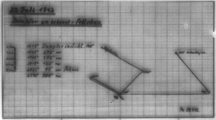
| 23.07.42 | Central Atlantic | ||||
| 00.00 | ES 5346 center | All preparations for surprise attack are made. The moon comes through the clouds frequently, then it is too bright. I will wait until moonset. | |||
| Moonshine, rain showers, Vis. changing | |||||
| 04.00 | ES 5233 center | The conditions at stations have been good for half an hour. The target is only very faintly distinguished in the targeting scope. | |||
| Gun leader reports target detected in the targeting optics. | |||||
| 06.02 | Target angle 120°, range = 500-600 meters. Permission to fire! The target optics are lost from the 10.5 cm after the 2nd shot; 3.7 cm is aimed over the rear sight and front sight; 4 shots 10.5 cm go too high and pass by laterally, the 3.7 cm also. | ||||
|
Sun and Moon Data 22.07.42 |
| Sun and Moon Data 23.07.42 |
- 17 - |
|||||
| continued | |||||
| 23.07.42 | |||||
| 06.05 | Steamer turns, showed a small silhouette. Because the surprise attack failed and gun leader reports that the target cannot be distinguished despite the in my opinion lowest range that is in question for us, broke off combat. | ||||
| 08.00 | ES 2887 lower-center | ||||
| 08.45 | Reported delayed arrival at supply by Radio Message. | ||||
| 12.00 | ES 5281 lower-center | Day's run: 206.0 Latitude 7°07'N | |||
| 6.9 Longitude: 24°03'W | |||||
| 212.9 | |||||
| 16.00 | ES 5582 upper-left | ||||
| 20.00 | ES 5855 | At economical speed and changing courses back and forth in supply square. | |||
| |
|||||
| 24.07.42 | Central Atlantic | Back and forth in position on changing course at economical speed. | |||
| Bright moon, SE 3-4, Sea 2-3, medium Swell | |||||
| 12.00 | ES 5855 | Latitude 5°33'N | |||
| Longitude: 23°58'W | |||||
| |
|||||
| 25.07.42 | Central Atlantic | ||||
| 03.05 | Exchanged Recognition Signals with "U-Schulte". Until the beginning of lightness stayed in visual range back and forth in the supply square. | ||||
| 09.15 | Smoke feather in sight. Schulte turned to pursue the steamer, I move off a bit. | ||||
| 09.40 | Schulte out of sight. | ||||
| 12.00 | ES 5855 | Steered changing courses in supply square. | |||
| |
|||||
| 26.07.42 | Central Atlantic | ||||
| 12.00 | ES 5855 | Tonight the boat has been in service for 1 year! | |||
| Steered changing search courses in supply square. | |||||
|
Sun and Moon Data 23.07.42 |
| Sun and Moon Data 24.07.42 | |
| Sun and Moon Data 25.07.42 | |
| Sun and Moon Data 26.07.42 |
- 18 - |
|||||
| continued | |||||
| 26.07.42 | |||||
| 18.30 | ES 5855 | "U-Schulte" in sight. | |||
| 20.30 | SSE 1-2, Sea 1, medium Swell, clear sky, Vis. good | Began fuel oil and provisions offload. | |||
| Offload: 45 cbm fuel oil, because Schulte still only had 25 cbm, and 1 weeks provisions. | |||||
| 23.30 | Offload was continued in moonshine until ended - released Schulte. | ||||
| |
|||||
| 27.07.42 | Central Atlantic | ||||
| 05.10 | Bright moonlit night, it freshens | Shadow in sight in 330°R on the horizon with course 90° and high not accurately determined speed. Apparently a large tanker. | |||
| 05.25 | Out of sight. No Radio Report sent because data is inexact and might endanger supply tomorrow. | ||||
| 12.00 | ES 5855 | Steered changing courses in supply square. | |||
| 15.33 | |||||
| to | Test dive. | ||||
| 16.03 | |
||||
| 28.07.42 | Central Atlantic | ||||
| 10.30 | "U-Kals" in sight. | ||||
| 10.43 | ES 5855 | "U-Schacht" in sight. | |||
| 12.30 | Sea 3, Sea 2-3, medium Swell, clear horizon | Began to supply Kals. Schacht protects at the limit of visibility.15.20 - 18.08 | |||
| Offload: 22 cbm fuel oil and 1 weeks provisions. In this weather provisions transfer can still be carried out with the inflatable boat and is thus considerably accelerated | |||||
| 14.55 | Offload to Kals ended. | ||||
| 15.20 | Began to supply Schacht, Kals as protection at the limit of visibility. | ||||
| Offload: 28 cbm fuel oil and 3 weeks provisions. | |||||
| 18.08 | Offload to Schacht ended. | ||||
| 20.36 | Released both boats. | ||||
| to | Test dive. | ||||
| 21.22 | |
||||
|
Sun and Moon Data 26.07.42 |
| Sun and Moon Data 27.07.42 | |
| Sun and Moon Data 28.07.42 |
- 19 - |
|||||
| 29.07.42 | Central Atlantic | ||||
| 12.00 | SbyE 2, Sea 1-2, medium Swell | At economical speed back and forth in position in supply square. | |||
| ES 5855 | |||||
| 20.00 | ES 4846 lower-left | |
|||
| 30.07.42 | Central Atlantic | ||||
| 00.00 | ES 5872 upper-left | ||||
| 04.00 | ES 8212 upper-left | ||||
| 08.00 | ES 5881 upper-right | ||||
| 12.00 | ES 5861 center | Day's run: 123.5 Latitude 5°40'N | |||
| Longitude: 23°45'W | |||||
| 16.00 | ES 5852 center | To save fuel stopped and let the boat drift. | |||
| 20.00 | ES 5852 upper-right | At the beginning of darkness again got underway and moved back and forth at economical speed. | |||
| |
|||||
| 31.07.42 | Central Atlantic | ||||
| 00.00 | ES 5855 upper-left | ||||
| S 2, Sea 1-2, medium Swell | |||||
| 04.00 | ES 5881 center | ||||
| 08.00 | ES 5882 center | ||||
| 10.30 | |||||
| to | Test dive - depth control training. | ||||
| 11.45 | |||||
| 12.00 | ES 5859 lower-left | Day's run: 72.5 Latitude 5°26'N | |||
| 2.5 Longitude: 24°05'W | |||||
| 16.00 | ES 5857 center | 75.0 | |||
| 20.00 | ES 5857 center | Let the boat drift in the afternoon. | |||
| |
|||||
| 01.08.42 | Central Atlantic | ||||
| 00.00 | ES 5858 lower-center | Headed for newly ordered supply square. | |||
| 04.00 | ES 5897 center-right | ||||
| 08.00 | ES 8317 upper-left | ||||
|
Sun and Moon Data 29.07.42 |
| Sun and Moon Data 30.07.42 | |
| Sun and Moon Data 31.07.42 | |
| Sun and Moon Data 01.08.42 |
- 20 - |
|||||
| continued | |||||
| 01.08.42 | |||||
| 12.00 | ES 8346 | Day's run: 84 Latitude 4°37'N | |||
| SSE 1-2, Sea 1, light Swell | Longitude: 23°18'W | ||||
| 16.00 | ES 8386 center-left | ||||
| 20.00 | ES 8386 | Boat lat stopped. | |||
| Hirsacker reports arrival for supply tomorrow at midday. | |||||
| |
|||||
| 02.08.42 | Central Atlantic | ||||
| 00.00 | ES 8397 center-right | Continued transit. | |||
| 04.00 | ES 9177 center | ||||
| 08.00 | ES 9187 center | ||||
| 12.00 | ES 9198 | Day's run: 88 Latitude 4°15'N | |||
| Longitude: 21°41'W | |||||
| 13.45 | ES 9277 | Exchanged Recognition Signals with "U-Hirsacker". | |||
| 16.00 | SSE 2, Sea 1-2, overcast, medium Swell | Began supply. | |||
| Offload: 50 cbm fuel oil, 3 weeks provisions. | |||||
| 19.30 | Offload ended - boat released. | ||||
| 20.08 | |||||
| to | Test dive. | ||||
| 20.40 | |
||||
| 03.08.42 | Central Atlantic | ||||
| 00.00 | Steered changing courses at low speed in the supply square. | ||||
| 12.00 | ES 9277 | ||||
| SSE 3, Sea 2-3, medium to high Swell, overcast | |
||||
| 04.08.42 | Central Atlantic | ||||
| 12.00 | ES 9277 | ||||
| 13.00 | Exchanged Recognition Signals with "U-Schroeter". | ||||
| 14.30 | SSE 1-2, Sea 1, medium Swell, overcast | Began supply. | |||
| Offload: 50 cbm fuel oil, 3 weeks provisions, 2 cbm lubricating oil. | |||||
| 19.30 | Offload ended. Released the boat. Test dive. | ||||
|
Sun and Moon Data 01.08.42 |
| Sun and Moon Data 02.08.42 | |
| Sun and Moon Data 03.08.42 | |
| Sun and Moon Data 04.08.42 |
- 21 - |
|||||
| continued | |||||
| 04.08.42 | |||||
| 20.18 | |||||
| to | Test dive. | ||||
| 20.43 | |||||
| 20.53 | Began return transit. | ||||
| |
|||||
| 05.08.42 | Central Atlantic | ||||
| 00.00 | ES 9159 center | ||||
| 04.00 | ES 9121 lower-right | ||||
| 08.00 | ES 6748 upper-center | ||||
| 09.15 | Began ordered fuel measurement. | ||||
| 12.00 | ES 5933 center-right | Day's run: 113.5 Latitude 5°38'N | |||
| SSW 2, Sea 1, overcast, rain showers | 1.0 Longitude: 22°38'W | ||||
| 114.5 | |||||
| 16.00 | ES 5664 center | ||||
| 20.00 | ES 5388 lower-right | |
|||
| 06.08.42 | Central | ||||
| 00.00 | ES 5343 | ||||
| 04.00 | ES 2974 center | ||||
| 08.00 | ES 2838 lower-right corner | ||||
| 12.00 | ES 2594 upper-left | Day's run: 185.1 Latitude 8°54'N | |||
| Longitude: 23°47'W | |||||
| 16.00 | ES 2528 center | ||||
| 20.00 | ES 2273 center | ||||
| N 1-2, Sea 1, starry clear | |
||||
| 07.08.42 | Central Atlantic | ||||
| 00.00 | ES 2214 center-right | ||||
| 01.10 | ES 2212 | A steamer with set lights and spot lights on the over deck comes in sight in 30°T. Course about 200-210°, speed 10-12 knots, range = 3-4 nm. | |||
| Marked as a neutral by lighting. Since the boat is taking fuel measurements, continued on. | |||||
|
Sun and Moon Data 04.08.42 |
| Sun and Moon Data 05.08.42 | |
| Sun and Moon Data 06.08.42 | |
| Sun and Moon Data 07.08.42 |
- 22 - |
|||||
| continued | |||||
| 07.08.42 | |||||
| 02.50 | Steamer out of sight in 155°T. | ||||
| 04.00 | EJ 8769 lower-left | ||||
| 08.00 | EJ 8734 center | ||||
| 09.14 | EJ 8489 | Fuel measurement ended. | |||
| Vessel in sight in 305°T (at lightness). | |||||
| 09.17 | Dived | ||||
| Normal type. The top masts have been removed. Stern cannon. About 4500 GRT. Apparently deck cargo aft between the wheelhouse and the mast. | |||||
| Course 80°, speed 10-12 knots. | |||||
| There are still about 15 hours until darkness. Therefore I let him go due to the bad experience of 22/23 July. | |||||
| 11.07 | Surfaced. | ||||
| 11.20 | Steamer out of sight. | ||||
| 12.00 | EJ 8489 center-left | Day's run: 167.5 Latitude 11°27'N | |||
| NW 1, clear horizon, fair, light Swell | 4.0 Longitude: 24°48'W | ||||
| 171.5 | |||||
| 16.00 | EJ 8446 upper-right | ||||
| 20.00 | EJ 8411 lower-left | |
|||
| 08.08.42 | Central Atlantic | ||||
| 00.00 | EJ 7365 lower-left | ||||
| 04.00 | EJ 7322 center | ||||
| 08.00 | EJ 4949 center | ||||
| 12.00 | EJ 4914 upper-left corner | Day's run: 174 Latitude 13°59'N | |||
| Longitude: 26°12'W | |||||
| 16.00 | EJ 4567 lower-center | ||||
| 20.00 | EJ 4526 center-left | |
|||
| 09.08.42 | Central Atlantic | ||||
| 00.00 | EJ 4259 center-left | ||||
| 04.00 | EJ 1889 lower-left | ||||
| 08.00 | EJ 1853 center | ||||
|
Sun and Moon Data 07.08.42 |
| Sun and Moon Data 08.08.42 | |
| Sun and Moon Data 09.08.42 |
- 23 - |
|||||
| continued | |||||
| 09.08.42 | |||||
| 10.59 | |||||
| to | Test dive. | ||||
| 11.32 | |||||
| 12.00 | EJ 1586 upper-center | Day's run: 183.5 Latitude 17°00'N | |||
| Trade Wind, changing cloudiness, isolated rain showers | 2.5 Longitude: 26°35'W | ||||
| 186.0 | |||||
| 16.00 | EJ 1537 | On course 20° and diesel-electric HF, headed for 15°W. | |||
| 20.00 | EJ 1295 | |
|||
| 10.08.42 | Central Atlantic | ||||
| 00.00 | EJ 1263 | ||||
| 04.00 | DT 7978 left lower edge | ||||
| 08.00 | DT 7946 center | ||||
| 12.00 | DT 7921 center | Day's run: 152 Latitude 19°28'N | |||
| Longitude: 25°52'W | |||||
| 16.00 | DT 7658 center | ||||
| 20.00 | DT 7634 lower-left corner | |
|||
| 11.08.42 | Central Atlantic | ||||
| 00.00 | DT 7369 center | ||||
| 04.00 | DT 8112 upper-center | ||||
| 08.00 | DT 5749 center | ||||
| 12.00 | DT 5725 lower-left corner | Day's run: 162 Latitude 22°02'N | |||
| Freshening NE-Trade Wind, medium Swell, overcast | 1 Longitude: 24°54'W | ||||
| 163 | |||||
| 10.00 | |||||
| to | Test dive. | ||||
| 10.30 | |||||
| 16.00 | DT 5459 lower-center | ||||
| 20.00 | DT 5435 upper-left corner | |
|||
| 12.08.42 | Central Atlantic | ||||
| 00.00 | DT 5169 upper-center | ||||
| 04.00 | DT 5212 upper-left corner | ||||
| 08.00 | DT 2846 center | ||||
|
Sun and Moon Data 09.08.42 |
| Sun and Moon Data 10.08.42 | |
| Sun and Moon Data 11.08.42 | |
| Sun and Moon Data 12.08.42 |
- 24 - |
|||||
| continued | |||||
| 12.08.42 | |||||
| 12.00 | DT 2588 | Day's run: 184 nm Latitude 24°52'N | |||
| Trade Wind 5-6, high Swell, clear sky | Longitude: 23°58'W | ||||
| 16.00 | DT 2556 center | ||||
| 20.00 | DT 2531 center | |
|||
| 13.08.42 | Central Atlantic | ||||
| 00.00 | DT 2268 | ||||
| 04.00 | DT 2236 center | ||||
| 08.00 | DH 7771 center | ||||
| 10.01 | |||||
| to | Test dive. | ||||
| 10.16 | |||||
| 12.00 | DH 7717 lower-right | Day's run: 144 Latitude 27°20'N | |||
| NE Trade Wind 4-5, Sea 4-5, medium Swell | 1 Longitude: 23°22'W | ||||
| 145 | |||||
| 16.00 | DH 7475 lower-right | ||||
| 20.00 | DH 7443 lower-right | |
|||
| 14.08.42 | Central Atlantic | ||||
| 15.08.42 | Central Atlantic | ||||
| 00.00 | DH 4544 lower-right | ||||
| 04.00 | DH 4515 center-right | ||||
| 08.00 | DN 4284 center-left | ||||
| 10.01 | |||||
| to | Test dive. | ||||
| 10.25 | |||||
| 12.00 | DH 4255 upper-center | Day's run: 125.8 Latitude 31°42'N | |||
| Abating Trade Wind, Sea 3 | 1.2 Longitude: 21°44'W | ||||
| 127.0 | |||||
| 16.00 | DH 1889 upper-right | ||||
| 20.00 | DH 1862 upper-center | |
|||
| [The entry for 15 August above is an insert which covers over the entry for 14 and part of 16 August] | |||||
| [The entries below are from 16 August] | |||||
| 12.00 | DH 15xx xx | Day's run: 1xx.8 Latitude 3x°xx'N | |||
| Trade Wind, clear, Vis. good | Longitude: 20°36'W | ||||
| 16.00 | CF 8864 lower-right | ||||
| 20.00 | CF 8599 center-right | |
|||
|
Sun and Moon Data 12.08.42 |
| Sun and Moon Data 13.08.42 | |
| Sun and Moon Data 14.08.42 | |
| Sun and Moon Data 15.08.42 | |
| Sun and Moon Data 16.08.42 |
- 25 - |
|||||
| 17.08.42 | North Atlantic | ||||
| 00.00 | CF 8642 upper-right | ||||
| Duck pond, lightly cloudy | |||||
| 04.00 | CF 8381 center-right | ||||
| 08.00 | CF 8326 lower-center | ||||
| 10.00 | |||||
| to | Test dive. | ||||
| 10.30 | |||||
| 12.00 | CF 5992 center | Day's run: 201.5 Latitude 37°47'N | |||
| N 1, duck pond, medium cloudy, partly haze | 1.5 Longitude: 18°52'W | ||||
| 203.0 | |||||
| To pass through the endangered area quickly went to transit speed RPM = 300. | |||||
| 15.15 | Strong smoke feather in sight bearing 199°T, which slowly shifted to the east. Range = over 12 nm. | ||||
| Ran at GF for 10 minutes. | |||||
| 15.35 | Out of sight in about 185°T. | ||||
| 16.00 | CF 6478 lower-left | ||||
| 20.00 | CF 6416 lower-left | |
|||
| 18.08.42 | North Atlantic | ||||
| 00.00 | CF 6181 lower-left | ||||
| Duck pond, marine phosphorescence, hazy | |||||
| 02.05 | CF 6158 | 2 shadows came in sight in the haze in about 100°T at about 8000 - 10000 meters. | |||
| Turned away hard and moved off on course 290° at GF. It becomes a bit clearer and little by little a total of 6 vessels are distinguished that are slowly approaching. | |||||
| Turned further to 250°. The range is now about 1000 - 1500 meters and then was slowly greater. | |||||
| With the prevailing haze it cannot be made out what type of vessels there are. | |||||
| 02.10 | Convoy out of sight. | ||||
| Moved off 30 minutes to the SE, then on the old | |||||
|
Sun and Moon Data 17.08.42 |
| Sun and Moon Data 18.08.42 |
- 26 - |
|||||
| continued | |||||
| 18.08.42 | |||||
| course and transit speed and reported the convoy by Radio Message. | |||||
| 04.00 | CF 6158 center | ||||
| 08.00 | CF 3874 lower-center | ||||
| 12.00 | CF 3828 center | Day's run: 261 nm Latitude 40°51'N | |||
| Longitude: 16°56'W | |||||
| 16.00 | CF 3675 upper-center | ||||
| 20.00 | CF 3637 center | ||||
| Wind shifted to S 1-2, Sea 1, medium cloudiness | |
||||
| 19.08.42 | North Atlantic | ||||
| 00.00 | CG 1173 center-right | ||||
| Wind shifted to W 2 | |||||
| 04.00 | CG 1136 center-left | ||||
| 08.00 | BE 9868 lower-left | ||||
| 12.00 | BE 9916 center-left | Day's run: 261 nm Latitude 43°40'N | |||
| Longitude: 12°39'W | |||||
| 13.05 | BE 9687 | Crash dive! Aircraft in about 20°T. As far as could be determined a 2-engined land-based aircraft on opposite course. | |||
| 14.40 | NW 3-4, medium cloudy, clear horizon, Sea 3, medium Swell | Surfaced to shoot the sun (midday latitude) to have an exact starting navigation fix for the submerged transit. | |||
| 15.47 | Dived. Began submerged transit at depth A -20 meters. | ||||
| 16.00 | BE 9686 upper-left | ||||
| At around 17.00 hours in the boat at depth A minus 20 meters, initially very distant depth charge detonations could be heard, which then became clearer, later entire depth charge series can be identified. | |||||
| At the same time the G.H.G. reports S-gear sounds of the own S-gear type, which were initially heard weakly in the K.D.B., then clearly distinguished. | |||||
| No detection, only rough bearings. | |||||
| No ship bearings of the sounds distinguished. | |||||
| 20.00 | BE 9692 center | ||||
|
Sun and Moon Data 18.08.42 |
| Sun and Moon Data 19.08.42 |
- 27 - |
|||||
| continued | |||||
| 19.08.42 | |||||
| 20.27 | NNW 2-3, Sea 2-3, clear horizon, medium cloudy | Surfaced to possibly determine the cause of the sounds. | |||
| Nothing determined. | |||||
| 21.50 | Dived. | ||||
| |
|||||
| 20.08.42 | Atlantic, exit of the Bay of Biscay | ||||
| 00.00 | BE 9669 center-right | ||||
| 04.00 | BF 7445 center | ||||
| 08.00 | BF 7451 center | ||||
| 10.00 | SSW 2, Sea 1-2 | Surfaced. | |||
| 12.00 | BF 7434 center-right | Day's run: 135 nm Latitude 44°13'N | |||
| Longitude: 11°18'W | |||||
| 12.57 | 2 masts and 1 smokestack in sight bearing 40°T. | ||||
| Dived. | |||||
| 14.20 | Surfaced to charge. | ||||
| 14.43 | In 50°T the same vessel in sight. | ||||
| Dived, to let the vessel run off. | |||||
| 16.00 | BF 7279 | Twice shortly after one another 2 very distant depth charge detonations were heard. | |||
| 17.08 | Surfaced. to charge. | ||||
| 18.30 | Ahead apparently the same steamer comes in sight again. | ||||
| On closer inspection, he turns out to be a tuna fisherman. Avoided on the surface. | |||||
| 19.29 | Due to bad visibility interrupted charging and dived. | ||||
| 20.00 | BF 7291 lower-left | ||||
| 21.55 | Quite close by, the sound of 7-10 shots, a volley like our Flak 30. Assume check fire of a boat surfacing in the vicinity. | ||||
| |
|||||
| 21.08.42 | Bay of Biscay | ||||
| 00.00 | BF 7292 center | ||||
| 04.00 | BF 7269 lower-center | ||||
| 08.00 | BF 7348 center | ||||
|
Sun and Moon Data 19.08.42 |
| Sun and Moon Data 20.08.42 | |
| Sun and Moon Data 21.08.42 |
The last page of the KTB is missing
| Enclosures to U-116's KTB - click on the text at left to proceed to the document | |
| Torpedo | Torpedo firing reports |
| Radio | Excerpt of the Radio Log |
Comments of the Befehlshabers der Unterseeboote |
|||
on the Kriegstagebuch "U 116" from 9.6.42 - 23.8.42. |
|||
|
|||
| 3rd patrol of the boat as a supply boat for a U-boat Group, on which 5 supplies were completed and 2 ships were sunk. | |||
| Nothing to note. | |||
 |
Signed in draft: D ö n i t z . |
||
For correctness: |
|||
 |
|||
Leutnant M.A. and Adjutant |
|||
|
Click the icons to view the associated records |
|||||
 |
Return to the U-boat KTB page | ||||